Renewable Energies in Land Management
The research focus under the direction of Prof. Dr. Martina Klärle, which emerged from the Geoinformation and Municipal Technology course of studies, offers a platform for innovative projects at the interface between geoinformatics and renewable energies. The main focus here is on the development of automated potential and location analyses for renewable energies on the basis of geodata available throughout the country. Modern geoinformation systems and applications based on them are used specifically to support local authorities on their way into the renewable energy age.
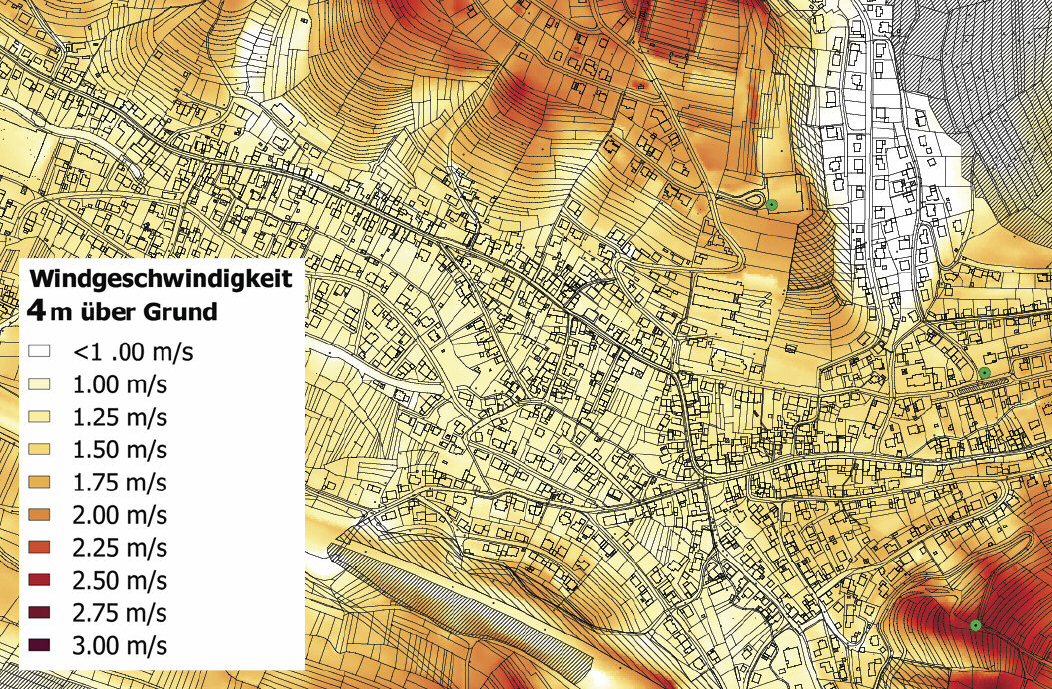
So far, small wind turbines can only rarely be operated economically because the exact wind speed near the ground is not known. WIND-AREA now provides an exact flow simulation on the basis of high-resolution remote sensing data, which takes topography, vegetation and buildings into account in detail. The aim is to locate locations with increased wind speeds due to small-scale currents without the need for complex test measurements. For the first time, it will be possible to provide large-scale proof of the most economical locations for small wind turbines, an important and hitherto untapped market area for energy system transformation. The research project was completed in 2014 and has already been put into practice for urban areas and rural communities.

As a result of the research project SUN-AREA, for which Prof. Dr. Martina Klärle was awarded the German Solar Prize in 2009, all roof surfaces that are optimally suited for the generation of solar energy can be determined fully automatically. There is now a SUN-AREA solar roof register for over 1,000 cities in Germany and abroad, which provides citizens with reliable information on the suitability of their roof and the cost-effectiveness of solar use. To determine suitable roof areas, high-resolution laser scan data are evaluated, which are obtained by means of flying. These are then combined with cadastral data; in addition, solar radiation is simulated throughout the day and year. This enables the exact calculation of the electricity yield to be expected from photovoltaic use for each individual roof area.

The research project ERNEUERBAR KOMM!, completed in 2011, enables for the first time a holistic area potential analysis for all forms of renewable energies. With the help of geo basic data, it is determined how much electricity can be generated from solar and wind energy, biomass and hydropower on the area of a community. The ERNEUERBAR KOMM! method has met with a great response from municipalities, counties and regions and has already been put into practice for more than 600 municipalities just a few months after completion of the research project.